Geolocate

Carmena topographic map

Click on the map to display elevation.

About this map

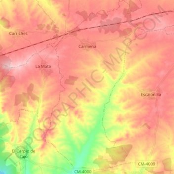
Name: Carmena topographic map, elevation, terrain.

Location: Carmena, Toledo, Castile-La Mancha, Spain (39.87435 -4.43646 39.98492 -4.35376)

Average elevation: 538 m

Minimum elevation: 419 m

Maximum elevation: 610 m

Other topographic maps

Click on a map to view its topography, its elevation and its terrain.

sinkhole

Spain > Castile-La Mancha > Pajarón

Average elevation: 1,042 m

Río Guadiana

Spain > Castile-La Mancha > La Mancha > Daimiel

Average elevation: 617 m

Gear up for your next adventure:

🧢Hiking Sun Hat - Wide-brimmed protection for exposed mountain ridges
🔦UV Flashlight - Detect minerals or specific insects in the dark
🥾Lightweight Hiking Boots - Boots for comfort and mobility on long hikes
Lightweight Backpacking Tent - Compact tent for efficient hiking trips
🌬️Windproof Camp Stove - Efficient cooking even on exposed mountain peaks

As an Amazon Associate, this site earns from qualifying purchases at no extra cost to you.