
Les Câbles topographic map
Click on the map to display elevation.
About this map
Name: Les Câbles topographic map, elevation, terrain.
Average elevation: 121 m
Minimum elevation: 21 m
Maximum elevation: 180 m
Other topographic maps
Click on a map to view its topography, its elevation and its terrain.
Équeurdreville-Hainneville
France > Normandie > Manche > Cherbourg-en-Cotentin
La ville est traversée en son centre par le ruisseau de la Bonde qui forme une petite vallée. D'autres ruisseaux (ruisseau du Fay, le Vaublat…) creusent également des sillons, créant des vaux et des encaissements. Équeurdreville-Hainneville est donc assez escarpée par endroits et l'altitude monte rapidement.
Average elevation: 60 m
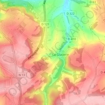
La Glacerie
France > Normandie > Manche > Cherbourg-en-Cotentin
Située à 178 mètres d'altitude au-dessus de Cherbourg, le climat y est plus froid que sur la côte et les jours de neige y sont trois fois plus nombreux qu'à Cherbourg, soit environ 15 jours par an.
Average elevation: 114 m
Ouvrage Saint-Gabriel
France > Normandie > Manche > Cherbourg-en-Cotentin > Les Charmettes
Average elevation: 90 m