Geolocate

Tourlaville topographic map

Click on the map to display elevation.

About this map

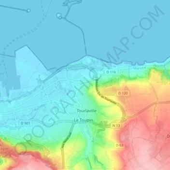
Name: Tourlaville topographic map, elevation, terrain.

Location: Tourlaville, Cherbourg-en-Cotentin, Cherbourg, Manche, Normandie, France métropolitaine, 50110, France (49.62024 -1.60536 49.67493 -1.53349)

Average elevation: 34 m

Minimum elevation: -1 m

Maximum elevation: 140 m

Other topographic maps

Click on a map to view its topography, its elevation and its terrain.

Les Câbles

France > Normandie > Manche > Cherbourg-en-Cotentin

Average elevation: 121 m

La Croix Luce

France > Normandie > Manche > Cherbourg-en-Cotentin

Average elevation: 111 m

Les Varendes

France > Normandie > Manche > Cherbourg-en-Cotentin

Average elevation: 77 m

Gear up for your next adventure:

🧴Outdoor Sunscreen - High SPF protection for high-altitude UV exposure
💧Collapsible Water Bottle - Space-saving water bottle for outdoor activities
💡LED Headlamp - Hands-free illumination for night hiking and camping
🩹Moleskin Blister Pads - Direct protection for painful foot pressure points
🎒Hiking Daypack - Lightweight and durable backpacks for day trips and excursions

As an Amazon Associate, this site earns from qualifying purchases at no extra cost to you.