
Make a donation
Gear up for your next adventure:
As an Amazon Associate, this site earns from qualifying purchases at no extra cost to you.
Équeurdreville-Hainneville topographic map
Click on the map to display elevation.
Make a donation
Gear up for your next adventure:
As an Amazon Associate, this site earns from qualifying purchases at no extra cost to you.
Équeurdreville-Hainneville
La ville est traversée en son centre par le ruisseau de la Bonde qui forme une petite vallée. D'autres ruisseaux (ruisseau du Fay, le Vaublat…) creusent également des sillons, créant des vaux et des encaissements. Équeurdreville-Hainneville est donc assez escarpée par endroits et l'altitude monte rapidement.
Make a donation
Gear up for your next adventure:
As an Amazon Associate, this site earns from qualifying purchases at no extra cost to you.
About this map
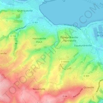
Name: Équeurdreville-Hainneville topographic map, elevation, terrain.
Average elevation: 60 m
Minimum elevation: -3 m
Maximum elevation: 152 m
Make a donation
Gear up for your next adventure:
As an Amazon Associate, this site earns from qualifying purchases at no extra cost to you.
Other topographic maps
Click on a map to view its topography, its elevation and its terrain.
Make a donation
Gear up for your next adventure:
As an Amazon Associate, this site earns from qualifying purchases at no extra cost to you.
Hameau Saint-Jean
France > Normandie > Manche > Cherbourg-en-Cotentin > Hameau Saint-Jean
Average elevation: 92 m
Make a donation
Gear up for your next adventure:
As an Amazon Associate, this site earns from qualifying purchases at no extra cost to you.
Ouvrage Saint-Gabriel
France > Normandie > Manche > Cherbourg-en-Cotentin > Les Charmettes
Average elevation: 90 m