
Thank you for supporting this site ❤️
Make a donation
Make a donation
Gear up for your next adventure:
As an Amazon Associate, this site earns from qualifying purchases at no extra cost to you.
Inverlochlarig topographic map
Click on the map to display elevation.
Thank you for supporting this site ❤️
Make a donation
Make a donation
Gear up for your next adventure:
As an Amazon Associate, this site earns from qualifying purchases at no extra cost to you.
About this map
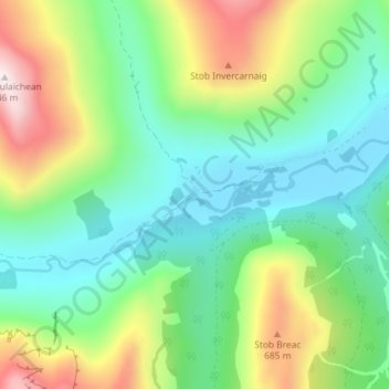
Name: Inverlochlarig topographic map, elevation, terrain.
Location: Inverlochlarig, Stirling, Scotland, FK19 8PH, United Kingdom (56.31012 -4.54801 56.35012 -4.50801)
Average elevation: 379 m
Minimum elevation: 125 m
Maximum elevation: 937 m
Thank you for supporting this site ❤️
Make a donation
Make a donation
Gear up for your next adventure:
As an Amazon Associate, this site earns from qualifying purchases at no extra cost to you.