Geolocate

Lebang topographic map

Click on the map to display elevation.

About this map

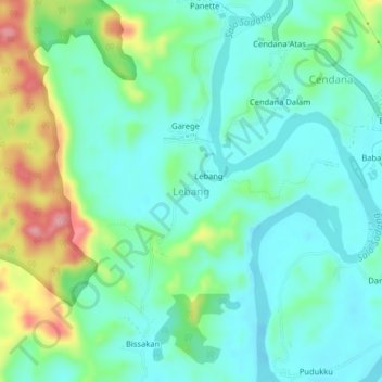
Name: Lebang topographic map, elevation, terrain.

Location: Lebang, Enrekang, South Sulawesi, Sulawesi, 91762, Indonesia (-3.65427 119.73789 -3.61427 119.77789)

Average elevation: 68 m

Minimum elevation: 27 m

Maximum elevation: 180 m

Other topographic maps

Click on a map to view its topography, its elevation and its terrain.

Baraka

Indonesia > South Sulawesi > Enrekang

Average elevation: 827 m

Malua

Indonesia > South Sulawesi > Enrekang

Average elevation: 709 m

Alla

Indonesia > South Sulawesi > Enrekang

Average elevation: 1,037 m

Bungin

Indonesia > South Sulawesi > Enrekang

Average elevation: 1,238 m

Cendana

Indonesia > South Sulawesi > Enrekang

Average elevation: 152 m

Maiwa

Indonesia > South Sulawesi > Enrekang

Average elevation: 214 m

Malua

Indonesia > South Sulawesi > Enrekang

Average elevation: 709 m

Buntu Batu

Indonesia > South Sulawesi > Enrekang

Average elevation: 1,459 m

Gear up for your next adventure:

💡Portable Camping Lamp - Rechargeable lamp for campsite lighting
🛏️Sleeping Bag - Warm and compact sleeping bags for outdoor camping
🧥Ultralight Puffy Jacket - Maximum warmth that packs down to the size of an orange
🐕Hiking Dog Pack - Let your canine companion carry their own water and food
🥾Light Hiking Boots - Lightweight and comfortable boots for day hikes

As an Amazon Associate, this site earns from qualifying purchases at no extra cost to you.