
Port Louis topographic map
Interactive map
Click on the map to display elevation.
About this map
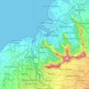
Name: Port Louis topographic map, elevation, terrain.
Location: Port Louis, Outer islands of Mauritius, Mauritius (-20.21547 57.41122 -20.13845 57.55656)
Average elevation: 142 m
Minimum elevation: -1 m
Maximum elevation: 760 m
Other topographic maps
Click on a map to view its topography, its elevation and its terrain.
Petite Rivière
Petite Rivière, Black River, Outer islands of Mauritius, Mauritius
Average elevation: 85 m
Curepipe
Mauritius > Plaines Wilhems > Curepipe
Curepipe, Plaines Wilhems, Mauritius
Average elevation: 536 m
Port-Louis
Mauritius > Port Louis > Port-Louis
Port-Louis, Port Louis, 11317, Mauritius
Average elevation: 144 m
Pamplemousses
Pamplemousses, Outer islands of Mauritius, 21013, Mauritius
Average elevation: 82 m
Port Louis
Port Louis, Outer islands of Mauritius, 11317, Mauritius
Average elevation: 142 m
Plaine Magnien
Mauritius > Grand Port > Plaine Magnien
Plaine Magnien, Grand Port, Mauritius
Average elevation: 86 m