Geolocate

Buckland topographic map

Click on the map to display elevation.

About this map

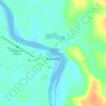
Name: Buckland topographic map, elevation, terrain.

Location: Buckland, Northwest Arctic, Alaska, 99727, United States (65.96971 -161.15212 65.99031 -161.11096)

Average elevation: 9 m

Minimum elevation: -6 m

Maximum elevation: 37 m

Other topographic maps

Click on a map to view its topography, its elevation and its terrain.

Kivalina

United States > Alaska > Northwest Arctic

Average elevation: 1 m

Kiana

United States > Alaska > Northwest Arctic > Kiana

Average elevation: 33 m

Noorvik

United States > Alaska > Northwest Arctic > Noorvik

Average elevation: 4 m

Shungnak

United States > Alaska > Northwest Arctic > Shungnak

Average elevation: 40 m

Ambler

United States > Alaska > Northwest Arctic

Average elevation: 45 m

Buckland

United States > Alaska > Northwest Arctic > Buckland

Average elevation: 13 m

Selawik

United States > Alaska > Northwest Arctic > Selawik

Average elevation: 1 m

Kobuk

United States > Alaska > Northwest Arctic

Average elevation: 94 m

Gear up for your next adventure:

🥾Hiking Shoes - Durable and comfortable shoes for trail hiking
🥾Trekking Boots - Durable boots for long-distance trekking
🩹Compact First Aid Kit - Pre-packed essentials for common trail injuries
🥾Waterproof Hiking Boots - Essential footwear for rugged terrain and wet Canadian trails
🧴Insect Repellent - Protect yourself from bugs during outdoor adventures

As an Amazon Associate, this site earns from qualifying purchases at no extra cost to you.