Geolocate

Danville topographic map

Click on the map to display elevation.

About this map

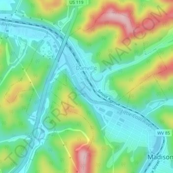
Name: Danville topographic map, elevation, terrain.

Location: Danville, Boone County, West Virginia, United States (38.06650 -81.85038 38.08958 -81.81802)

Average elevation: 280 m

Minimum elevation: 202 m

Maximum elevation: 442 m

Other topographic maps

Click on a map to view its topography, its elevation and its terrain.

Andrew

United States > West Virginia > Boone County

Average elevation: 394 m

Lory

United States > West Virginia > Boone County

Average elevation: 313 m

Bob White

United States > West Virginia > Boone County

Average elevation: 410 m

Nellis

United States > West Virginia > Boone County

Average elevation: 328 m

Gear up for your next adventure:

🧼Biodegradable Camp Soap - Environmentally friendly cleaning for gear and body
Tent Footprint - Protect tent floor and increase durability
🧰Emergency Multi-Tool - Compact multi-tool for outdoor survival
🔪Outdoor Multitool - Versatile tool for repairs and food prep in the wild
🥾All-Terrain Hiking Boots - Versatile boots for varied hiking conditions

As an Amazon Associate, this site earns from qualifying purchases at no extra cost to you.