Geolocate

Andrew topographic map

Click on the map to display elevation.

About this map

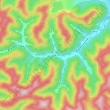
Name: Andrew topographic map, elevation, terrain.

Location: Andrew, Boone County, West Virginia, 25154, United States (38.08013 -81.73740 38.12013 -81.69740)

Average elevation: 394 m

Minimum elevation: 238 m

Maximum elevation: 553 m

Other topographic maps

Click on a map to view its topography, its elevation and its terrain.

Danville

United States > West Virginia > Boone County

Average elevation: 280 m

Gear up for your next adventure:

🛁Quick-Dry Microfiber Towel - Space-saving towel that dries rapidly on the move
🌡️Emergency Mylar Blankets - Compact thermal protection for unexpected nights outdoors
🔋Solar Power Bank - Keep your GPS and devices charged during long outdoor trips
🔨Vehicle Emergency Tool - Safety tool for remote road trips to trailheads
Camping Tent - Weather-resistant tents suitable for 2 to 6 people

As an Amazon Associate, this site earns from qualifying purchases at no extra cost to you.