Geolocate

Hoy topographic map

Click on the map to display elevation.

About this map

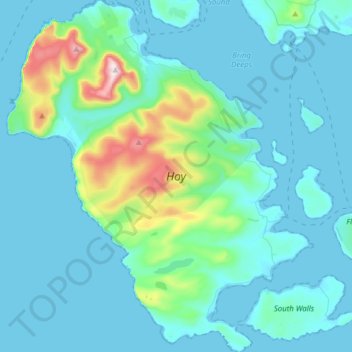
Name: Hoy topographic map, elevation, terrain.

Location: Hoy, Rackwick, Orkney Islands, Scotland, United Kingdom (58.77180 -3.43587 58.93229 -3.16937)

Average elevation: 58 m

Minimum elevation: 0 m

Maximum elevation: 478 m

Gear up for your next adventure:

🧢Hiking Hat - Sun-protective and breathable hats for long treks
💧Reusable Water Bottle - Durable water bottles for hydration on trails
Camping Tent - Weather-resistant tents suitable for 2 to 6 people
🧦Merino Wool Socks - Moisture-wicking comfort for long-distance hiking
🧥Packable Rain Jacket - Breathable waterproof layer for unpredictable weather

As an Amazon Associate, this site earns from qualifying purchases at no extra cost to you.