Geolocate

Sutton topographic map

Click on the map to display elevation.

About this map

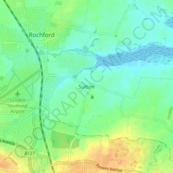
Name: Sutton topographic map, elevation, terrain.

Location: Sutton, Rochford, Essex, England, SS4 1LJ, United Kingdom (51.55188 0.70226 51.59188 0.74226)

Average elevation: 11 m

Minimum elevation: -1 m

Maximum elevation: 30 m

Other topographic maps

Click on a map to view its topography, its elevation and its terrain.

Hullbridge

United Kingdom > England > Essex > Rochford > Hullbridge

Average elevation: 20 m

Rochford

United Kingdom > England > Essex > Rochford > Stroud Green

Average elevation: 26 m

Ashingdon

United Kingdom > England > Essex > Rochford

Average elevation: 14 m

Sutton

United Kingdom > England > Essex > Rochford > Sutton

Average elevation: 10 m

Foulness Island

United Kingdom > England > Essex > Rochford

Average elevation: 1 m

Potash Woods

United Kingdom > England > Essex > Rochford > Hawkwell

Average elevation: 29 m

Foulness Island

United Kingdom > England > Essex > Rochford

Average elevation: 1 m

Gear up for your next adventure:

🥾Trekking Poles - Adjustable trekking poles to reduce knee stress and improve stability
🥫Freeze-Dried Meals - Lightweight, high-calorie nutrition for multi-day treks
🎒Hiking Backpack - Lightweight and ergonomic backpacks for day hikes or multi-day treks
🥾Waterproof Trail Shoes - Shoes designed to handle wet terrain
🧴Sunscreen SPF - Broad-spectrum sunscreen for outdoor activities

As an Amazon Associate, this site earns from qualifying purchases at no extra cost to you.