Geolocate

Tarano topographic map

Click on the map to display elevation.

About this map

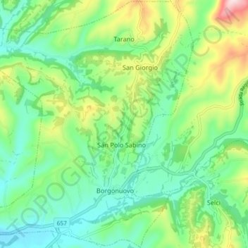
Name: Tarano topographic map, elevation, terrain.

Location: Tarano, Rieti, Lazio, Italy (42.31096 12.54287 42.36408 12.61523)

Average elevation: 186 m

Minimum elevation: 76 m

Maximum elevation: 434 m

Other topographic maps

Click on a map to view its topography, its elevation and its terrain.

Monticchio

Italy > Lazio > Rieti > Monte San Giovanni in Sabina

Average elevation: 778 m

Poggio Corese

Italy > Lazio > Rieti

Average elevation: 353 m

Villanova

Italy > Lazio > Rieti > Accumoli

Average elevation: 1,041 m

Pian de' Valli

Italy > Lazio > Rieti > Rieti > Pian de' Valli

Average elevation: 1,529 m

Gear up for your next adventure:

Bushcraft Tarp - Versatile emergency shelter or gear protection
🥤Collapsible Travel Cup - Saves space and weight in your mess kit
👟Trail Running Shoes - Agile footwear for fast-paced topographic exploration
🥘Camping Cookware Set - Compact nesting pots and pans for trail cooking
🧢Outdoor Cap - Protective cap for sun and rain during hikes

As an Amazon Associate, this site earns from qualifying purchases at no extra cost to you.