Geolocate

Canfield topographic map

Click on the map to display elevation.

About this map

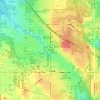
Name: Canfield topographic map, elevation, terrain.

Location: Canfield, Mahoning County, Ohio, 44406, United States (41.01335 -80.79160 41.05405 -80.73915)

Average elevation: 347 m

Minimum elevation: 313 m

Maximum elevation: 376 m

Gear up for your next adventure:

🧭GPS Tracker - Track your location in remote areas safely
🥾All-Terrain Hiking Boots - Versatile boots for varied hiking conditions
💧Hydration Bladder - Hands-free hydration solution for long treks
🦶Anti-Blister Balm - Prevents friction and hotspots during long ascents
🚲Bike Repair Kit - Essential tools for on-trail mechanical issues

As an Amazon Associate, this site earns from qualifying purchases at no extra cost to you.