Geolocate

Buckingham topographic map

Click on the map to display elevation.

About this map

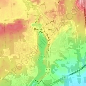
Name: Buckingham topographic map, elevation, terrain.

Location: Buckingham, Gatineau, Outaouais, Quebec, Canada (45.55941 -75.45234 45.59912 -75.38932)

Average elevation: 124 m

Minimum elevation: 58 m

Maximum elevation: 186 m

Quebec trails, hiking, mountain biking, running and outdoor activities

Other topographic maps

Click on a map to view its topography, its elevation and its terrain.

Pink Lake

Canada > Quebec > Gatineau

Average elevation: 153 m

Parc de la Cité

Canada > Quebec > Gatineau

Average elevation: 58 m

Lac Beauchamp

Canada > Quebec > Gatineau

Average elevation: 56 m

Boisé de l'étrier

Canada > Quebec > Gatineau

Average elevation: 56 m

Gear up for your next adventure:

💧Filtered Water Bottle - Safe drinking water on the go
Camping Groundsheet - Protect your tent from moisture and dirt
🧴Outdoor Sunscreen - High SPF protection for high-altitude UV exposure
🥾Hiking Leggings - Comfortable leggings for outdoor activities
🥫Freeze-Dried Meals - Lightweight, high-calorie nutrition for multi-day treks

As an Amazon Associate, this site earns from qualifying purchases at no extra cost to you.