Geolocate

Hull topographic map

Click on the map to display elevation.

About this map

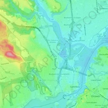
Name: Hull topographic map, elevation, terrain.

Location: Hull, Gatineau, Outaouais, Quebec, Canada (45.41239 -75.79685 45.49022 -75.69306)

Average elevation: 66 m

Minimum elevation: 38 m

Maximum elevation: 173 m

Quebec trails, hiking, mountain biking, running and outdoor activities

Other topographic maps

Click on a map to view its topography, its elevation and its terrain.

Pink Lake

Canada > Quebec > Gatineau

Average elevation: 153 m

Parc de la Cité

Canada > Quebec > Gatineau

Average elevation: 58 m

Lac Beauchamp

Canada > Quebec > Gatineau

Average elevation: 56 m

Boisé de l'étrier

Canada > Quebec > Gatineau

Average elevation: 56 m

Gear up for your next adventure:

🥾Hiking Shoes - Durable and comfortable shoes for trail hiking
🥽Outdoor Goggles - Protective eyewear for outdoor activities
🧭Orienteering Kit - Tools for map reading and navigation in the wild
🧢Outdoor Visor - Breathable visor for sunny hikes
🔪Outdoor Multitool - Versatile tool for repairs and food prep in the wild

As an Amazon Associate, this site earns from qualifying purchases at no extra cost to you.