Geolocate

South Freeport topographic map

Click on the map to display elevation.

About this map

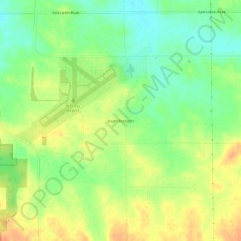
Name: South Freeport topographic map, elevation, terrain.

Location: South Freeport, Stephenson County, Illinois, United States (42.22086 -89.59261 42.26086 -89.55261)

Average elevation: 254 m

Minimum elevation: 234 m

Maximum elevation: 274 m

Other topographic maps

Click on a map to view its topography, its elevation and its terrain.

Lena

United States > Illinois > Stephenson County

Average elevation: 279 m

Cedarville

United States > Illinois > Stephenson County

Average elevation: 255 m

Freeport

United States > Illinois > Stephenson County

Average elevation: 244 m

Freeport

United States > Illinois > Stephenson County

Average elevation: 244 m

Freeport

United States > Illinois > Stephenson County

Average elevation: 244 m

Gear up for your next adventure:

👟Leg Gaiters - Keep debris, mud, and snow out of your boots
🛶Kayak Accessories - Essential gear for safe and fun kayaking adventures
🥾Light Trekking Boots - Supportive boots for multi-day treks
Camping Essentials - All-in-one gear for a comfortable camping trip
🧦Hiking Socks - Moisture-wicking and comfortable socks for long hikes

As an Amazon Associate, this site earns from qualifying purchases at no extra cost to you.