Geolocate

Freeport topographic map

Click on the map to display elevation.

About this map

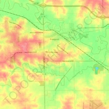
Name: Freeport topographic map, elevation, terrain.

Location: Freeport, Stephenson County, Illinois, 61032, United States (42.24932 -89.68657 42.32140 -89.57764)

Average elevation: 244 m

Minimum elevation: 205 m

Maximum elevation: 275 m

Other topographic maps

Click on a map to view its topography, its elevation and its terrain.

Gear up for your next adventure:

🥾Waterproof Hiking Shoes - Durable shoes for wet and rugged trails
🏕️Camping Hammock - Integrated protection for sleeping between trees
Lightweight Backpacking Tent - Compact tent for efficient hiking trips
🥤Collapsible Travel Cup - Saves space and weight in your mess kit
Backpacking Tent - Lightweight tent for long-distance hiking trips

As an Amazon Associate, this site earns from qualifying purchases at no extra cost to you.