
Coleraine topographic map
Click on the map to display elevation.
About this map
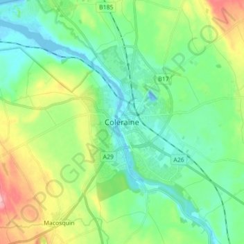
Name: Coleraine topographic map, elevation, terrain.
Average elevation: 40 m
Minimum elevation: -14 m
Maximum elevation: 138 m
Other topographic maps
Click on a map to view its topography, its elevation and its terrain.
Causeway Coast and Glens District
United Kingdom > Northern Ireland > County Londonderry
Average elevation: 101 m
Drumahoe
United Kingdom > Northern Ireland > County Londonderry > Derry/Londonderry
Average elevation: 46 m
Lough Foyle
United Kingdom > Northern Ireland > County Londonderry > Londonderry/Derry
Average elevation: 61 m
Ballymagroarty
United Kingdom > Northern Ireland > County Londonderry > Derry/Londonderry
Average elevation: 73 m
Mid-Ulster District Council
United Kingdom > Northern Ireland > County Londonderry
Average elevation: 112 m
Foyle
United Kingdom > Northern Ireland > County Londonderry > Derry/Londonderry
Average elevation: 48 m
Magilligan - Benone Strand
United Kingdom > Northern Ireland > County Londonderry > Castlerock > Downhill
Average elevation: 22 m
Eglinton Registrars District
United Kingdom > Northern Ireland > County Londonderry > Greysteel
Average elevation: 87 m
Foyle
United Kingdom > Northern Ireland > County Londonderry > Derry/Londonderry
Average elevation: 48 m
Bay Road Park
United Kingdom > Northern Ireland > County Londonderry > Derry/Londonderry
Average elevation: 19 m