Geolocate

Dutzow topographic map

Click on the map to display elevation.

About this map

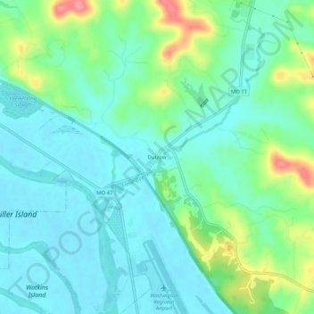
Name: Dutzow topographic map, elevation, terrain.

Location: Dutzow, Warren County, Missouri, 63342, United States (38.58436 -91.01630 38.62436 -90.97630)

Average elevation: 166 m

Minimum elevation: 143 m

Maximum elevation: 229 m

Other topographic maps

Click on a map to view its topography, its elevation and its terrain.

Warrenton

United States > Missouri > Warren County

Average elevation: 248 m

Wright City

United States > Missouri > Warren County

Average elevation: 219 m

Pendleton

United States > Missouri > Warren County

Average elevation: 271 m

Innsbrook

United States > Missouri > Warren County

Average elevation: 232 m

Warrenton

United States > Missouri > Warren County

Average elevation: 248 m

Wright City

United States > Missouri > Warren County

Average elevation: 219 m

Marthasville

United States > Missouri > Warren County

Average elevation: 166 m

Warrenton

United States > Missouri > Warren County

Average elevation: 248 m

Gear up for your next adventure:

🛶Canoe Life Vest - Safety vest for water sports
🛰️Satellite Messenger - Emergency communication for areas with no cell service
Family Camping Tent - Spacious tent suitable for family camping trips
🥾Hiking Leggings - Comfortable leggings for outdoor activities
🧥Waterproof Hiking Jacket - Protect yourself from rain and wind while hiking

As an Amazon Associate, this site earns from qualifying purchases at no extra cost to you.