
Warrenton topographic map
Click on the map to display elevation.
About this map
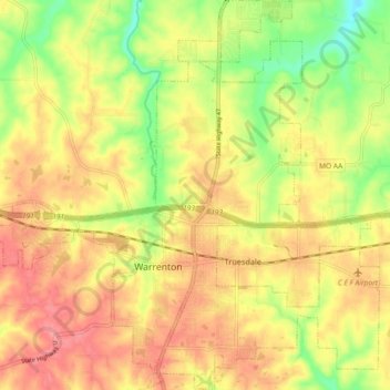
Name: Warrenton topographic map, elevation, terrain.
Location: Warrenton, Warren County, Missouri, 63383, United States (38.78840 -91.23218 38.85948 -91.08599)
Average elevation: 248 m
Minimum elevation: 190 m
Maximum elevation: 287 m
Other topographic maps
Click on a map to view its topography, its elevation and its terrain.
Little Lost Creek Conservation Area
United States > Missouri > Warren County > Pendleton
Average elevation: 241 m