Geolocate

Oberiberg topographic map

Click on the map to display elevation.

About this map

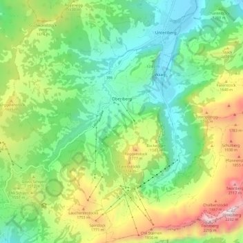
Name: Oberiberg topographic map, elevation, terrain.

Location: Oberiberg, Schwyz, 8843, Switzerland (46.99447 8.73294 47.06960 8.84390)

Average elevation: 1,369 m

Minimum elevation: 901 m

Maximum elevation: 2,269 m

Other topographic maps

Click on a map to view its topography, its elevation and its terrain.

Rickenbach bei Schwyz

Switzerland > Schwyz > Schwyz > Schwyz

Average elevation: 751 m

Bös Fulen

Switzerland > Schwyz > Schwyz > Muotathal

Average elevation: 2,206 m

Brunnen

Switzerland > Schwyz > Schwyz

Average elevation: 592 m

Ibach

Switzerland > Schwyz > Schwyz > Schwyz

Average elevation: 555 m

Mythen

Switzerland > Schwyz > Schwyz > Schwyz

Average elevation: 1,219 m

Rigi First

Switzerland > Schwyz > Schwyz > Arth

Average elevation: 1,198 m

Chäppeliberg

Switzerland > Schwyz > Schwyz > Schwyz

Average elevation: 1,115 m

Rickenbach

Switzerland > Schwyz > Schwyz > Schwyz

Average elevation: 751 m

Rigi

Switzerland > Schwyz > Schwyz > Arth

Average elevation: 1,266 m

Gear up for your next adventure:

🧴Bear Spray Holster - Quick-access carry for essential Canadian wilderness safety
🎒Fully Waterproof Backpack - Total protection for photography gear and electronics
🥾Lightweight Hiking Shoes - Comfortable shoes for day hikes
💡LED Headlamp - Hands-free illumination for night hiking and camping
🧣Evaporative Cooling Towel - Beat the heat during intense summer climbs

As an Amazon Associate, this site earns from qualifying purchases at no extra cost to you.