Geolocate

Chäppeliberg topographic map

Click on the map to display elevation.

About this map

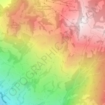
Name: Chäppeliberg topographic map, elevation, terrain.

Location: Chäppeliberg, Schwyz, 6430, Switzerland (47.04039 8.64938 47.06039 8.66938)

Average elevation: 1,115 m

Minimum elevation: 551 m

Maximum elevation: 1,556 m

Other topographic maps

Click on a map to view its topography, its elevation and its terrain.

Mythen

Switzerland > Schwyz > Schwyz > Schwyz

Average elevation: 1,219 m

Gear up for your next adventure:

Lightweight Camping Tent - Portable shelter optimized for Canadian backcountry camping
🧰Survival Kit - Essential gear for emergencies in the wilderness
🗺️Topographic Maps - Detailed maps to explore trails, mountains, and wilderness areas
🦟Insect Repellent - Keep mosquitoes and black flies away in wooded areas
🥾Hiking Gaiters - Protect legs and shoes from mud, snow, and debris

As an Amazon Associate, this site earns from qualifying purchases at no extra cost to you.