
Make a donation
Gear up for your next adventure:
As an Amazon Associate, this site earns from qualifying purchases at no extra cost to you.
Kazabazua topographic map
Click on the map to display elevation.
Make a donation
Gear up for your next adventure:
As an Amazon Associate, this site earns from qualifying purchases at no extra cost to you.
Kazabazua
The village and municipality are named after the Kazabazua River which passes through it. Like many other First Nations names, Kazabazua has had many spellings in English, such as Kazaluzu, Kasubasua, Cazabasua, Cazibazouis, Cazebalzuac, Cajibajouis. This word comes from the Algonquin word kachibadjiwan, from kach ("hidden") and djiwan ("current"), hence it means "underground river". This name is a reflection of the local topography because the Kazabazua River disappears underground and resurfaces a few dozen metres (yards) downstream. The river then flows through rapids and passes under a natural stone bridge.
Make a donation
Gear up for your next adventure:
As an Amazon Associate, this site earns from qualifying purchases at no extra cost to you.
About this map
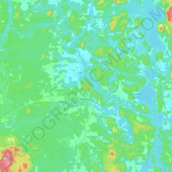
Name: Kazabazua topographic map, elevation, terrain.
Average elevation: 178 m
Minimum elevation: 138 m
Maximum elevation: 359 m
La Vallée-de-la-Gatineau trails, hiking, mountain biking, running and outdoor activities
Make a donation
Gear up for your next adventure:
As an Amazon Associate, this site earns from qualifying purchases at no extra cost to you.
Other topographic maps
Click on a map to view its topography, its elevation and its terrain.
Île Laflamme
Canada > Quebec > La Vallée-de-la-Gatineau > Sainte-Thérèse-de-la-Gatineau
Average elevation: 248 m
Make a donation
Gear up for your next adventure:
As an Amazon Associate, this site earns from qualifying purchases at no extra cost to you.
Make a donation
Gear up for your next adventure:
As an Amazon Associate, this site earns from qualifying purchases at no extra cost to you.
Sainte-Thérèse-de-Gatineau
Canada > Quebec > La Vallée-de-la-Gatineau > Sainte-Thérèse-de-la-Gatineau
Average elevation: 180 m
Make a donation
Gear up for your next adventure:
As an Amazon Associate, this site earns from qualifying purchases at no extra cost to you.
Make a donation
Gear up for your next adventure:
As an Amazon Associate, this site earns from qualifying purchases at no extra cost to you.