Geolocate

Yi County topographic map

Click on the map to display elevation.

About this map
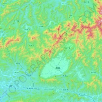
Name: Yi County topographic map, elevation, terrain.

Location: Yi County, Huangshan, Anhui, China (29.79145 117.64432 30.19528 118.10120)

Average elevation: 399 m

Minimum elevation: 104 m

Maximum elevation: 1,600 m

Other topographic maps

Click on a map to view its topography, its elevation and its terrain.

Xiakengcun

China > Anhui > Huangshan

Average elevation: 221 m

Xidi

China > Anhui > Huangshan

Average elevation: 295 m

Huangsan Village

China > Anhui > Huangshan

Average elevation: 427 m

Gear up for your next adventure:

🧶550 Survival Paracord - Versatile utility cord for emergency repairs and rigging
🩹Moleskin Blister Pads - Direct protection for painful foot pressure points
🧢Hiking Hat - Sun-protective and breathable hats for long treks
🧢Sun Protection Cap - Breathable cap to protect from sun exposure
❄️Traction Ice Cleats - Slip-on spikes for icy trails and winter hiking

As an Amazon Associate, this site earns from qualifying purchases at no extra cost to you.