Geolocate

Xidi topographic map

Click on the map to display elevation.

About this map

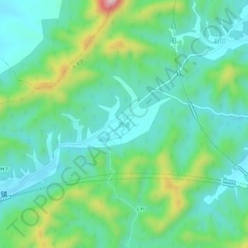
Name: Xidi topographic map, elevation, terrain.

Location: Xidi, Huangshan, Anhui, China (29.88611 117.97129 29.92611 118.01129)

Average elevation: 295 m

Minimum elevation: 202 m

Maximum elevation: 568 m

Other topographic maps

Click on a map to view its topography, its elevation and its terrain.

Xiuning County

China > Anhui > Huangshan

Average elevation: 375 m

Liyang

China > Anhui > Huangshan

Average elevation: 143 m

Qimen County

China > Anhui > Huangshan

Average elevation: 344 m

Huangshan District

China > Anhui > Huangshan

Average elevation: 405 m

Gear up for your next adventure:

🧦Hiking Socks - Moisture-wicking and comfortable socks for long hikes
🔦LED Headtorch - Bright and durable light for night activities
🛏️Camping Sleeping Mat - Comfortable mats for sleeping outdoors
💧Filtered Water Bottle - Safe drinking water on the go
👟Leg Gaiters - Keep debris, mud, and snow out of your boots

As an Amazon Associate, this site earns from qualifying purchases at no extra cost to you.