
Mushin topographic map
Interactive map
Click on the map to display elevation.
About this map
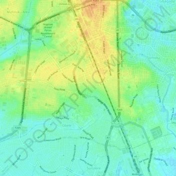
Name: Mushin topographic map, elevation, terrain.
Location: Mushin, Lagos State, 102215, Nigeria (6.49975 3.32362 6.55832 3.37095)
Average elevation: 14 m
Minimum elevation: 1 m
Maximum elevation: 33 m
Other topographic maps
Click on a map to view its topography, its elevation and its terrain.
Tincan Island
Nigeria > Lagos State > Apapa
Tincan Island, Apapa, Lagos State, Nigeria
Average elevation: 3 m
Makoko
Nigeria > Lagos State > Lagos Mainland
Makoko, Lagos Mainland, Lagos State, Nigeria
Average elevation: 3 m
Ikate
Nigeria > Lagos State > Eti Osa
Ikate, Eti Osa, Lagos State, 105102, Nigeria
Average elevation: 3 m
Oshodi/Isolo
Nigeria > Lagos State > Oshodi/Isolo
Oshodi/Isolo, Lagos State, 100263, Nigeria
Average elevation: 17 m
Igbo
Nigeria > Lagos State > Eti Osa
Igbo, Eti Osa, Lagos State, 500001, Nigeria
Average elevation: 5 m
Lagos
Nigeria > Lagos State > Lagos Island
Lagos, Lagos Island, Lagos State, 100242, Nigeria
Average elevation: 5 m
Lekki
Nigeria > Lagos State > Ibeju Lekki
Lekki, Ibeju Lekki, Lagos State, Nigeria
Average elevation: 2 m