
Ajah topographic map
Interactive map
Click on the map to display elevation.
About this map
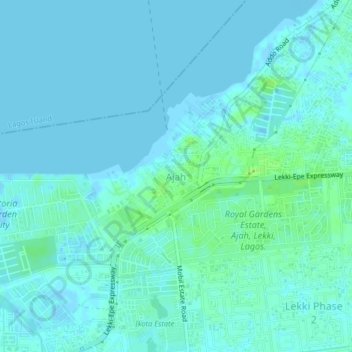
Name: Ajah topographic map, elevation, terrain.
Location: Ajah, Eti Osa, Lagos State, Nigeria (6.44947 3.54239 6.48947 3.58239)
Average elevation: 3 m
Minimum elevation: -3 m
Maximum elevation: 11 m
Other topographic maps
Click on a map to view its topography, its elevation and its terrain.
Ikate
Nigeria > Lagos State > Eti Osa
Ikate, Eti Osa, Lagos State, 105102, Nigeria
Average elevation: 3 m
Igbo
Nigeria > Lagos State > Eti Osa
Igbo, Eti Osa, Lagos State, 500001, Nigeria
Average elevation: 5 m