
Make a donation
Gear up for your next adventure:
As an Amazon Associate, this site earns from qualifying purchases at no extra cost to you.
Grisons topographic map
Click on the map to display elevation.
Make a donation
Gear up for your next adventure:
As an Amazon Associate, this site earns from qualifying purchases at no extra cost to you.
Grisons
The Grisons lies fully within the Alps, with elevations above sea-level ranging from 260 to 4,049 metres (853 to 13,284 ft). It is both one of the highest and lowest cantons, and the second-highest when considering mean elevation. As a consequence, its topography is extremely rugged and many of the highest settlements in the country (and Europe) are found there, notably in the Upper Engadin. The mountains are numerous; well over 1,000 summits are in the canton. The highest is Piz Bernina, closely followed by numerous peaks in the homonymous range. Other prominent mountains are Piz Russein, Piz Kesch, Calanda, Aroser Rothorn and Rheinwaldhorn, see list of mountains of Graubünden for a more exhaustive list. The canton includes numerous subranges of the Alps other than the Bernina. These are the Albula, the Bregaglia, the Glarus, the Gotthard, the Lepontine, the Livigno, the Plessur, the Oberhalbstein, the Ortler, the Rätikon, the Samnaun, the Sesvenna and the Silvretta ranges.
Make a donation
Gear up for your next adventure:
As an Amazon Associate, this site earns from qualifying purchases at no extra cost to you.
About this map
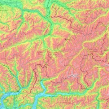
Name: Grisons topographic map, elevation, terrain.
Location: Grisons, Switzerland (46.16918 8.65106 47.06515 10.49229)
Average elevation: 1,737 m
Minimum elevation: 189 m
Maximum elevation: 4,001 m
Make a donation
Gear up for your next adventure:
As an Amazon Associate, this site earns from qualifying purchases at no extra cost to you.
Other topographic maps
Click on a map to view its topography, its elevation and its terrain.
Remis
Switzerland > St. Gallen > Wahlkreis Toggenburg > Kirchberg (SG) > Kirchberg SG
Average elevation: 717 m
Lausanne
Switzerland > Vaud > District de Lausanne > Lausanne
The most important geographical feature of the area surrounding Lausanne is Lake Geneva (Lac Léman in French). Lausanne is built on the southern slope of the Swiss plateau, with a difference in elevation of about 500 metres (1,640 ft) between the lakeshore at Ouchy and its northern edge bordering Le…
Average elevation: 577 m
Make a donation
Gear up for your next adventure:
As an Amazon Associate, this site earns from qualifying purchases at no extra cost to you.
Monte Rosa
Switzerland > Wallis > Visp > Zermatt
The peak is distinguished by the name Dufourspitze (in German, lit. Dufour Peak; French: Pointe Dufour, Italian: Punta Dufour). This replaced the former name Höchste Spitze (English: Highest Peak) that was indicated on the Swiss maps before the Federal Council, on January 28, 1863, decided to rename the…
Average elevation: 4,033 m
Filisur
Switzerland > Grisons > Albula > Bergün Filisur
Before 2017, the municipality was located in the Bergün subdistrict of the Albula district, since 2017 it is part of the Albula Region. It consists of the village of Filisur and the hamlet of Jenisberg at an elevation of 1,504 m (4,934 ft).
Average elevation: 1,319 m
Make a donation
Gear up for your next adventure:
As an Amazon Associate, this site earns from qualifying purchases at no extra cost to you.
Ramosch
Switzerland > Grisons > Region Engiadina Bassa/Val Müstair > Valsot
Average elevation: 1,501 m
Make a donation
Gear up for your next adventure:
As an Amazon Associate, this site earns from qualifying purchases at no extra cost to you.
Mathon
Switzerland > Grisons > Viamala > Muntogna da Schons > Donat
Before 2017, the former municipality was located in the Schams sub-district, of the Hinterrhein district, after 2017 it was part of the Viamala Region. The village is a haufendorf (an irregular, unplanned and quite closely packed village, built around a central square) at an elevation of 1,521 m (4,990 ft) in…
Average elevation: 1,520 m
Make a donation
Gear up for your next adventure:
As an Amazon Associate, this site earns from qualifying purchases at no extra cost to you.
Gmünde
Switzerland > Bern > Emmental administrative district > Langnau im Emmental
Average elevation: 1,013 m
Make a donation
Gear up for your next adventure:
As an Amazon Associate, this site earns from qualifying purchases at no extra cost to you.
Make a donation
Gear up for your next adventure:
As an Amazon Associate, this site earns from qualifying purchases at no extra cost to you.
Mattenbachfälle
Switzerland > Bern > Interlaken-Oberhasli administrative district > Stechelberg
Average elevation: 1,689 m
Port
Switzerland > Bern > Frutigen-Niedersimmental administrative district > Adelboden > Schönbühl
Average elevation: 1,415 m
Make a donation
Gear up for your next adventure:
As an Amazon Associate, this site earns from qualifying purchases at no extra cost to you.