Geolocate

Rio Lacramarca topographic map

Click on the map to display elevation.

About this map

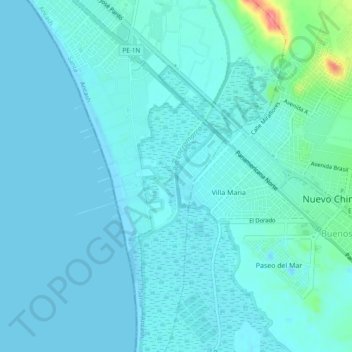
Name: Rio Lacramarca topographic map, elevation, terrain.

Location: Rio Lacramarca, Chimbote, Santa, Áncash, 02710, Perú (-9.14259 -78.55892 -9.09560 -78.54600)

Average elevation: 9 m

Minimum elevation: -5 m

Maximum elevation: 78 m

Other topographic maps

Click on a map to view its topography, its elevation and its terrain.

La Rinconada

Perú > Áncash > Chimbote

Average elevation: 135 m

Nuevo Vinzos

Perú > Áncash > Chimbote

Average elevation: 197 m

Alto Peru

Perú > Áncash > Chimbote

Average elevation: 62 m

San José

Perú > Áncash > Chimbote

Average elevation: 114 m

Cascajal Bajo

Perú > Áncash > Chimbote

Average elevation: 160 m

Vincas

Perú > Áncash > Chimbote

Average elevation: 200 m

Chuquicara

Perú > Áncash > Chimbote

Average elevation: 898 m

Cambio Puente

Perú > Áncash > Chimbote

Average elevation: 109 m

Cambio Puente

Perú > Áncash > Chimbote

Average elevation: 109 m

Gear up for your next adventure:

🚑Survival Whistle - Signal for help across long distances in mountains
💧Hydration Pack - Hands-free hydration system for long hikes
🔋Lithium AA Batteries - Long-lasting power that performs in extreme cold
Lightweight Backpacking Tent - Compact tent for efficient hiking trips
🥾Approach Boots - Comfortable boots for hiking and climbing approaches

As an Amazon Associate, this site earns from qualifying purchases at no extra cost to you.