Geolocate

Vincas topographic map

Click on the map to display elevation.

About this map

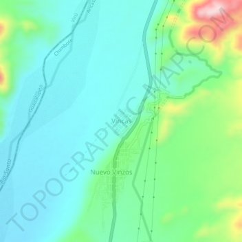
Name: Vincas topographic map, elevation, terrain.

Location: Vincas, Chimbote, Santa, Áncash, Perú (-8.82279 -78.57253 -8.78279 -78.53253)

Average elevation: 200 m

Minimum elevation: 125 m

Maximum elevation: 446 m

Other topographic maps

Click on a map to view its topography, its elevation and its terrain.

Rio Lacramarca

Perú > Áncash > Chimbote

Average elevation: 9 m

Gear up for your next adventure:

💧Collapsible Water Bottle - Space-saving water bottle for outdoor activities
🧰Emergency Multi-Tool - Compact multi-tool for outdoor survival
💧Hydration Pack - Hands-free hydration system for long hikes
🧤Insulated Winter Gloves - Heavy-duty protection for sub-zero Canadian adventures
🔭Outdoor Binoculars - Lightweight binoculars for birdwatching and hiking

As an Amazon Associate, this site earns from qualifying purchases at no extra cost to you.