Geolocate

Gullane topographic map

Click on the map to display elevation.

About this map

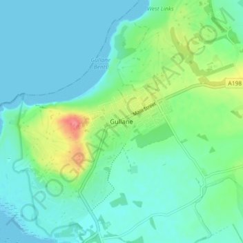
Name: Gullane topographic map, elevation, terrain.

Location: Gullane, East Lothian, Scotland, EH31 2AA, United Kingdom (56.01504 -2.85071 56.05504 -2.81071)

Average elevation: 16 m

Minimum elevation: 0 m

Maximum elevation: 68 m

Other topographic maps

Click on a map to view its topography, its elevation and its terrain.

Firth of Forth

United Kingdom > Scotland > East Lothian

Average elevation: 87 m

Lammermuirs

United Kingdom > Scotland > East Lothian

Average elevation: 266 m

Bass Rock

United Kingdom > Scotland > East Lothian

Average elevation: 0 m

Coldale Wood

United Kingdom > Scotland > East Lothian

Average elevation: 65 m

Gear up for your next adventure:

🥾Mountaineering Boots - Supportive boots for climbing and high-altitude hiking
🌬️Windproof Camp Stove - Efficient cooking even on exposed mountain peaks
🥾Trail Hiking Boots - Supportive boots for rough trails
🧊Portable Cooler - Keep food and drinks cold during outdoor adventures
🧴First Aid Kit - Essential first aid supplies for outdoor emergencies

As an Amazon Associate, this site earns from qualifying purchases at no extra cost to you.