
Make a donation
Gear up for your next adventure:
As an Amazon Associate, this site earns from qualifying purchases at no extra cost to you.
Volta Mantovana topographic map
Click on the map to display elevation.
Make a donation
Gear up for your next adventure:
As an Amazon Associate, this site earns from qualifying purchases at no extra cost to you.
About this map
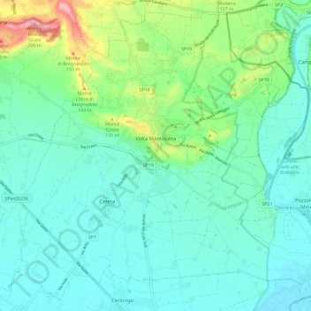
Name: Volta Mantovana topographic map, elevation, terrain.
Location: Volta Mantovana, Mantua, Lombardy, 46049, Italy (45.27967 10.60972 45.35404 10.72357)
Average elevation: 73 m
Minimum elevation: 38 m
Maximum elevation: 198 m
Make a donation
Gear up for your next adventure:
As an Amazon Associate, this site earns from qualifying purchases at no extra cost to you.
Other topographic maps
Click on a map to view its topography, its elevation and its terrain.
Make a donation
Gear up for your next adventure:
As an Amazon Associate, this site earns from qualifying purchases at no extra cost to you.
Forte di Pietole
Italy > Lombardy > Mantua > Borgo Virgilio > Pietole > Pietole Vecchia
Average elevation: 19 m