Geolocate

Groveland topographic map

Click on the map to display elevation.

About this map

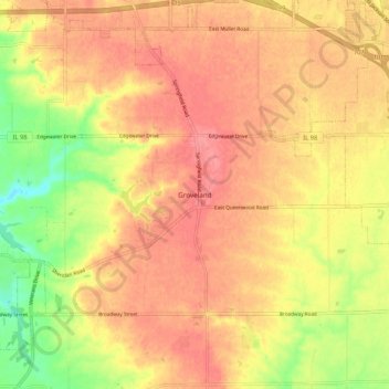
Name: Groveland topographic map, elevation, terrain.

Location: Groveland, Tazewell County, Illinois, 61535, United States (40.57254 -89.55454 40.61254 -89.51454)

Average elevation: 227 m

Minimum elevation: 194 m

Maximum elevation: 243 m

Other topographic maps

Click on a map to view its topography, its elevation and its terrain.

Washington

United States > Illinois > Tazewell County

Average elevation: 236 m

East Peoria

United States > Illinois > Tazewell County

Average elevation: 176 m

Pekin

United States > Illinois > Tazewell County

Average elevation: 158 m

Morton

United States > Illinois > Tazewell County

Average elevation: 219 m

East Peoria

United States > Illinois > Tazewell County

Average elevation: 176 m

Morton

United States > Illinois > Tazewell County

Average elevation: 219 m

Mackinaw

United States > Illinois > Tazewell County

Average elevation: 198 m

Morton

United States > Illinois > Tazewell County

Average elevation: 219 m

Brock Lake

United States > Illinois > Tazewell County > Mackinaw

Average elevation: 188 m

East Peoria

United States > Illinois > Tazewell County

Average elevation: 176 m

Deer Creek

United States > Illinois > Tazewell County

Average elevation: 227 m

Green Valley

United States > Illinois > Tazewell County

Average elevation: 164 m

Washington

United States > Illinois > Tazewell County

Average elevation: 236 m

Gear up for your next adventure:

🐕Hiking Dog Pack - Let your canine companion carry their own water and food
🧥Waterproof Jacket - Lightweight rain jackets for hiking and outdoor activities
❄️Traction Ice Cleats - Slip-on spikes for icy trails and winter hiking
🚲Heavy Duty Bike Lock - Secure your bike at the trailhead or during stops
🥾Durable Hiking Shoes - Long-lasting shoes for frequent hiking

As an Amazon Associate, this site earns from qualifying purchases at no extra cost to you.