Geolocate

Mackinaw topographic map

Click on the map to display elevation.

About this map

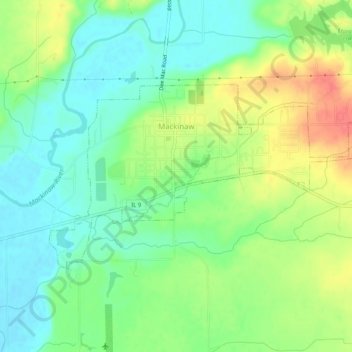
Name: Mackinaw topographic map, elevation, terrain.

Location: Mackinaw, Tazewell County, Illinois, United States (40.52130 -89.37596 40.54144 -89.32507)

Average elevation: 198 m

Minimum elevation: 174 m

Maximum elevation: 237 m

Other topographic maps

Click on a map to view its topography, its elevation and its terrain.

Groveland

United States > Illinois > Tazewell County

Average elevation: 227 m

Allentown

United States > Illinois > Tazewell County

Average elevation: 205 m

Brock Lake

United States > Illinois > Tazewell County > Mackinaw

Average elevation: 188 m

Gear up for your next adventure:

👟Sport Hiking Sandals - Breathable footwear for water crossings and camp rest
🥾Mountaineering Boots - Supportive boots for climbing and high-altitude hiking
🥾Light Hiking Boots - Lightweight and comfortable boots for day hikes
🗺️Topographic Maps - Detailed maps to explore trails, mountains, and wilderness areas
Camping Groundsheet - Protect your tent from moisture and dirt

As an Amazon Associate, this site earns from qualifying purchases at no extra cost to you.