Geolocate

Morton topographic map

Click on the map to display elevation.

About this map

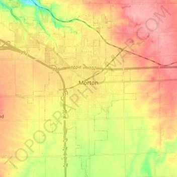
Name: Morton topographic map, elevation, terrain.

Location: Morton, Tazewell County, Illinois, 61550, United States (40.55614 -89.51667 40.66225 -89.42163)

Average elevation: 219 m

Minimum elevation: 163 m

Maximum elevation: 260 m

Other topographic maps

Click on a map to view its topography, its elevation and its terrain.

Groveland

United States > Illinois > Tazewell County

Average elevation: 227 m

Allentown

United States > Illinois > Tazewell County

Average elevation: 205 m

Brock Lake

United States > Illinois > Tazewell County > Mackinaw

Average elevation: 188 m

Gear up for your next adventure:

🥾Approach Boots - Comfortable boots for hiking and climbing approaches
🕶️Polarized Sunglasses - Protect your eyes with durable polarized lenses
🧢Hiking Hat - Sun-protective and breathable hats for long treks
🛁Quick-Dry Microfiber Towel - Space-saving towel that dries rapidly on the move
🧴Insect Repellent - Protect yourself from bugs during outdoor adventures

As an Amazon Associate, this site earns from qualifying purchases at no extra cost to you.