
Angeles topographic map
Interactive map
Click on the map to display elevation.
About this map
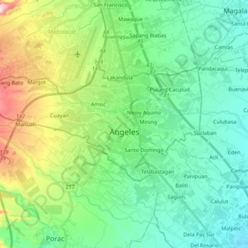
Name: Angeles topographic map, elevation, terrain.
Location: Angeles, Pampanga, Central Luzon, Philippines (15.10817 120.47807 15.17941 120.63715)
Average elevation: 98 m
Minimum elevation: 21 m
Maximum elevation: 312 m
Sapangbato is the largest barangay in Angeles in terms of territory, with a total land area of 104,694 sq. meters and a population of 11,262. Located northwest of Angeles near Clark Freeport Zone, it is identified as the barangay in Angeles with the highest elevation of 750 feet above sea level. It is home to Fort Stotsenburg, also known as the Parade Grounds of Clark. apl.de.ap, member of the hip hop group The Black Eyed Peas, hails from Sapangbato. The famous Puning Hot Springs of Barangay Inararo in Porac are accessed through Sitio Target in Sapangbato.
Other topographic maps
Click on a map to view its topography, its elevation and its terrain.
Manuali
Philippines > Pampanga > Porac
Manuali, Porac, Pampanga, Central Luzon, 2023, Philippines
Average elevation: 199 m
Minalin
Minalin, Pampanga, Central Luzon, 2019, Philippines
Average elevation: 4 m
Masantol
Masantol, Pampanga, Central Luzon, 2017, Philippines
Average elevation: 2 m
Calulut
Philippines > Pampanga > San Fernando
Calulut, San Fernando, Pampanga, Central Luzon, 2015, Philippines
Average elevation: 40 m
Santo Niño
Philippines > Pampanga > San Simon
Santo Niño, San Simon, Pampanga, Central Luzon, 2016, Philippines
Average elevation: 4 m
Paligui
Philippines > Pampanga > Candaba
Paligui, Candaba, Pampanga, Central Luzon, 2013, Philippines
Average elevation: 8 m
Macabebe
Macabebe, Pampanga, Central Luzon, 2018, Philippines
Average elevation: 3 m
Apalit
Apalit, Pampanga, Central Luzon, 2016, Philippines
Average elevation: 4 m
Floridablanca
Floridablanca, Pampanga, Central Luzon, 2006, Philippines
Average elevation: 24 m
Purok 1
Philippines > Pampanga > San Fernando > San Juan
Purok 1, San Juan, San Fernando, Pampanga, Central Luzon, 2000, Philippines
Average elevation: 7 m
Magalang
Magalang, Pampanga, Central Luzon, 2011, Philippines
Average elevation: 69 m
San Simon
San Simon, Pampanga, Central Luzon, Philippines
Average elevation: 5 m
Mabalacat
Mabalacat, Pampanga, Central Luzon, Philippines
Average elevation: 117 m
Telabastagan
Philippines > Pampanga > San Fernando
Telabastagan, San Fernando, Pampanga, Central Luzon, 2000, Philippines
Average elevation: 67 m
San Fernando
Philippines > Pampanga > San Fernando
San Fernando, Pampanga, Central Luzon, 20, Philippines
Average elevation: 24 m