Geolocate

San Simon topographic map

Click on the map to display elevation.

About this map

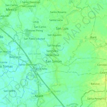
Name: San Simon topographic map, elevation, terrain.

Location: San Simon, Pampanga, Central Luzon, Philippines (14.97684 120.72708 15.03449 120.87462)

Average elevation: 5 m

Minimum elevation: -2 m

Maximum elevation: 13 m

Other topographic maps

Click on a map to view its topography, its elevation and its terrain.

Masantol

Philippines > Pampanga

Average elevation: 2 m

Manuali

Philippines > Pampanga > Porac

Average elevation: 199 m

Floridablanca

Philippines > Pampanga

Average elevation: 24 m

Santo Rosario

Philippines > Pampanga > Magalang

Average elevation: 49 m

Minalin

Philippines > Pampanga

Average elevation: 4 m

Macabebe

Philippines > Pampanga

Average elevation: 3 m

Purok 1

Philippines > Pampanga > San Fernando > San Juan

Average elevation: 7 m

Santo Niño

Philippines > Pampanga > San Simon

Average elevation: 4 m

Telabastagan

Philippines > Pampanga > San Fernando

Average elevation: 67 m

Gear up for your next adventure:

🧥Insulated Jacket - Keep warm in cold outdoor conditions
🧊Portable Cooler - Keep food and drinks cold during outdoor adventures
🥾Lightweight Hiking Boots - Boots for comfort and mobility on long hikes
Camping Groundsheet - Protect your tent from moisture and dirt
🧥Waterproof Hiking Jacket - Protect yourself from rain and wind while hiking

As an Amazon Associate, this site earns from qualifying purchases at no extra cost to you.