Geolocate

Pleasant Plains topographic map

Click on the map to display elevation.

About this map

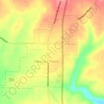
Name: Pleasant Plains topographic map, elevation, terrain.

Location: Pleasant Plains, Independence County, Arkansas, 72568, United States (35.54601 -91.64236 35.56504 -91.61713)

Average elevation: 180 m

Minimum elevation: 130 m

Maximum elevation: 211 m

Other topographic maps

Click on a map to view its topography, its elevation and its terrain.

Desha

United States > Arkansas > Independence County

Average elevation: 97 m

Gainsboro

United States > Arkansas > Independence County

Average elevation: 131 m

Bethesda

United States > Arkansas > Independence County

Average elevation: 167 m

Salado

United States > Arkansas > Independence County

Average elevation: 114 m

Bryant

United States > Arkansas > Independence County > Southside

Average elevation: 109 m

Charlotte

United States > Arkansas > Independence County

Average elevation: 123 m

Cord

United States > Arkansas > Independence County

Average elevation: 93 m

Limedale

United States > Arkansas > Independence County

Average elevation: 139 m

Pfeiffer

United States > Arkansas > Independence County

Average elevation: 138 m

Thida

United States > Arkansas > Independence County

Average elevation: 96 m

Cushman

United States > Arkansas > Independence County > Cushman > Cushman

Average elevation: 207 m

Floral

United States > Arkansas > Independence County

Average elevation: 236 m

Gear up for your next adventure:

🧣Merino Neck Gaiter - Protects against wind, sun, and cold at high altitudes
Camping Essentials - All-in-one gear for a comfortable camping trip
🧊Portable Cooler - Keep food and drinks cold during outdoor adventures
🧰Multitool Knife - Compact and versatile tool for outdoor use
🧤Insulated Winter Gloves - Heavy-duty protection for sub-zero Canadian adventures

As an Amazon Associate, this site earns from qualifying purchases at no extra cost to you.