Geolocate

Locust Grove topographic map

Click on the map to display elevation.

About this map

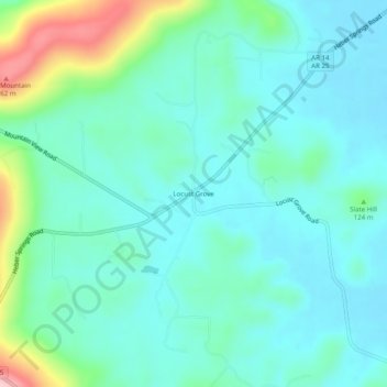
Name: Locust Grove topographic map, elevation, terrain.

Location: Locust Grove, Independence County, Arkansas, 72550, United States (35.70091 -91.75847 35.74091 -91.71847)

Average elevation: 125 m

Minimum elevation: 80 m

Maximum elevation: 292 m

Other topographic maps

Click on a map to view its topography, its elevation and its terrain.

Southside

United States > Arkansas > Independence County

The elevation of Southside is 354 feet (108 m).

Average elevation: 112 m

Cushman

United States > Arkansas > Independence County

Average elevation: 199 m

Magness

United States > Arkansas > Independence County

Average elevation: 85 m

Gear up for your next adventure:

📷Outdoor Action Camera - Capture high-elevation views and rugged adventures
🛶Kayak Dry Bag - Waterproof storage for kayaking adventures
🥾Hiking Shoes - Durable and comfortable shoes for trail hiking
🧭GPS Tracker - Track your location in remote areas safely
🥤Collapsible Travel Cup - Saves space and weight in your mess kit

As an Amazon Associate, this site earns from qualifying purchases at no extra cost to you.