Geolocate

Desha topographic map

Click on the map to display elevation.

About this map

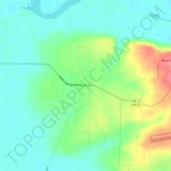
Name: Desha topographic map, elevation, terrain.

Location: Desha, Independence County, Arkansas, 72527, United States (35.71619 -91.69986 35.75619 -91.65986)

Average elevation: 97 m

Minimum elevation: 72 m

Maximum elevation: 149 m

Other topographic maps

Click on a map to view its topography, its elevation and its terrain.

Southside

United States > Arkansas > Independence County

The elevation of Southside is 354 feet (108 m).

Average elevation: 112 m

Cushman

United States > Arkansas > Independence County

Average elevation: 199 m

Magness

United States > Arkansas > Independence County

Average elevation: 85 m

Gear up for your next adventure:

💧Hydration Bladder - Hands-free hydration solution for long treks
🦌Outdoor Trail Camera - Monitor wildlife activity near your favorite spots
🔭Outdoor Binoculars - Lightweight binoculars for birdwatching and hiking
🧭GPS Outdoor Watch - Smart watch for navigation and fitness tracking in nature
👟Sport Hiking Sandals - Breathable footwear for water crossings and camp rest

As an Amazon Associate, this site earns from qualifying purchases at no extra cost to you.