Make a donation
Gear up for your next adventure:
As an Amazon Associate, this site earns from qualifying purchases at no extra cost to you.
Hincaster topographic map
Click on the map to display elevation.
Make a donation
Gear up for your next adventure:
As an Amazon Associate, this site earns from qualifying purchases at no extra cost to you.
About this map
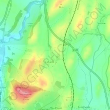
Name: Hincaster topographic map, elevation, terrain.
Location: Hincaster, South Lakeland, Cumbria, England, United Kingdom (54.24600 -2.76638 54.26819 -2.73999)
Average elevation: 51 m
Minimum elevation: 6 m
Maximum elevation: 124 m
Make a donation
Gear up for your next adventure:
As an Amazon Associate, this site earns from qualifying purchases at no extra cost to you.
Other topographic maps
Click on a map to view its topography, its elevation and its terrain.
Make a donation
Gear up for your next adventure:
As an Amazon Associate, this site earns from qualifying purchases at no extra cost to you.
Make a donation
Gear up for your next adventure:
As an Amazon Associate, this site earns from qualifying purchases at no extra cost to you.
Preston Patrick
United Kingdom > England > Cumbria > South Lakeland > Endmoor
Average elevation: 101 m
Storrs
United Kingdom > England > Cumbria > South Lakeland > Bowness-on-Windermere
Average elevation: 93 m
Make a donation
Gear up for your next adventure:
As an Amazon Associate, this site earns from qualifying purchases at no extra cost to you.
Whitestone Moss
United Kingdom > England > Cumbria > South Lakeland > High Nibthwaite > Houkler Hall
Average elevation: 102 m
Deerbolts Wood
United Kingdom > England > Cumbria > South Lakeland > Elterwater
Average elevation: 145 m
Make a donation
Gear up for your next adventure:
As an Amazon Associate, this site earns from qualifying purchases at no extra cost to you.
Make a donation
Gear up for your next adventure:
As an Amazon Associate, this site earns from qualifying purchases at no extra cost to you.
