
sumberejo topographic map
Interactive map
Click on the map to display elevation.
About this map
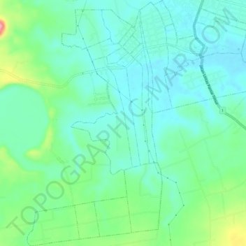
Name: sumberejo topographic map, elevation, terrain.
Location: sumberejo, Lampung Timur, Lampung, Indonésie (-5.22891 105.66485 -5.17692 105.71429)
Average elevation: 35 m
Minimum elevation: 4 m
Maximum elevation: 128 m
Other topographic maps
Click on a map to view its topography, its elevation and its terrain.
Bandar Lampung
Bandar Lampung, Lampung, Sumatra, Indonésie
Average elevation: 145 m
Balam
Indonésie > Lampung > Pesisir Barat > Balam
Balam, Pesisir Barat, Lampung, Indonésie
Average elevation: 525 m
Kebonjeruk
Indonésie > Lampung > Bandar Lampung > Kebonjeruk
Kebonjeruk, Bandar Lampung, Lampung, 35121, Indonésie
Average elevation: 124 m
Krakatau
Indonésie > Lampung > Lampung Selatan
Krakatau, Lampung Selatan, Lampung, Sumatra, Indonésie
Average elevation: 20 m