Geolocate

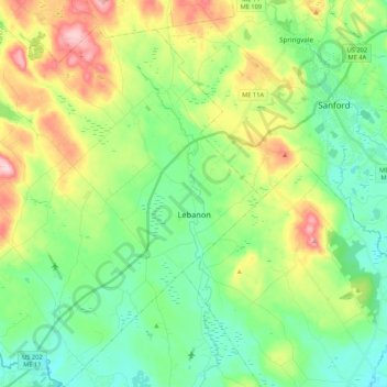
Lebanon topographic map

Click on the map to display elevation.

Lebanon

According to the United States Census Bureau, the town has a total area of 55.83 square miles (144.60 km2), of which 55.00 square miles (142.45 km2) is land and 0.83 square miles (2.15 km2) is water. Lebanon is drained by the Little River and Salmon Falls River. The town's highest point is Prospect Hill, at an elevation of 880 feet (268 m) above sea level. The lowest elevation borders the Salmon Falls River, on the town's southernmost boundary, which is approximately 170 feet (52 m) above sea level.

Wikipedia (CC-BY-SA 3.0)

About this map

Name: Lebanon topographic map, elevation, terrain.

Location: Lebanon, York County, Maine, 04027, United States (43.32569 -70.98843 43.48059 -70.81347)

Average elevation: 121 m

Minimum elevation: 51 m

Maximum elevation: 267 m

Other topographic maps

Click on a map to view its topography, its elevation and its terrain.

Boon Island

United States > Maine > York County > York

Average elevation: 0 m

Lake Sherburne

United States > Maine > York County > Waterboro

Average elevation: 142 m

Wells Beach

United States > Maine > York County > Wells

Average elevation: 1 m

Jamaica Island

United States > Maine > York County > Kittery

Average elevation: 31 m

Parsons Beach

United States > Maine > York County > Kennebunk

Average elevation: 3 m

Crescent Beach

United States > Maine > York County > Kittery

Average elevation: 5 m

Rotary Park

United States > Maine > York County > Kennebunk > Kennebunk

Average elevation: 18 m

Mount Agamenticus

United States > Maine > York County > York

Average elevation: 92 m

Boon Island

United States > Maine > York County > York

Average elevation: 0 m

Mount Agamenticus

United States > Maine > York County > York

Average elevation: 92 m

Rotary Park

United States > Maine > York County > Kennebunk > Kennebunk

Average elevation: 18 m

Ogunquit Beach

United States > Maine > York County > Ogunquit

Average elevation: 11 m

Holdsworth Park

United States > Maine > York County > Sanford

Average elevation: 130 m

Gear up for your next adventure:

🥾Durable Hiking Shoes - Long-lasting shoes for frequent hiking
🥾Mountain Hiking Shoes - Shoes with superior grip for mountainous terrain
🧭Orienteering Kit - Tools for map reading and navigation in the wild
🧢Beanie Hat - Keep your head warm in cold weather
🗺️Topographic Maps - Detailed maps to explore trails, mountains, and wilderness areas

As an Amazon Associate, this site earns from qualifying purchases at no extra cost to you.