Geolocate

Buchrain topographic map

Click on the map to display elevation.

About this map

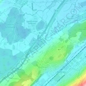
Name: Buchrain topographic map, elevation, terrain.

Location: Buchrain, Lucerne, 6033, Switzerland (47.08806 8.32769 47.11563 8.36542)

Average elevation: 429 m

Minimum elevation: 411 m

Maximum elevation: 541 m

Other topographic maps

Click on a map to view its topography, its elevation and its terrain.

Hellbühl

Switzerland > Lucerne

Average elevation: 639 m

Marbachegg

Switzerland > Lucerne > Escholzmatt-Marbach

Average elevation: 1,159 m

Gunzwil

Switzerland > Lucerne

Average elevation: 671 m

Schiltalp

Switzerland > Lucerne > Kriens

Average elevation: 962 m

Alpach

Switzerland > Lucerne > Escholzmatt-Marbach > Escholzmatt

Average elevation: 966 m

Sörenberg

Switzerland > Lucerne

Average elevation: 1,386 m

Schloss Meggenhorn

Switzerland > Lucerne > Meggen

Average elevation: 450 m

Allmendhubel

Switzerland > Lucerne > Menznau

Average elevation: 636 m

Schachen

Switzerland > Lucerne > Werthenstein > Schachen

Average elevation: 671 m

Gear up for your next adventure:

🧳Compression Sacks - Maximize space in your backpack by shrinking gear
🧊Insulated Water Bottle - Keeps drinks cold in summer and prevents freezing in winter
🥾Trail Running Boots - Durable shoes designed for trail running
🔭Outdoor Binoculars - Lightweight binoculars for birdwatching and hiking
🥾Trekking Boots - Durable boots for long-distance trekking

As an Amazon Associate, this site earns from qualifying purchases at no extra cost to you.