Geolocate

Montagnano topographic map

Click on the map to display elevation.

About this map

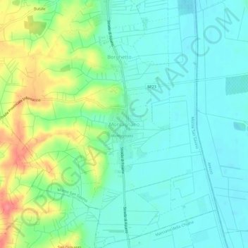
Name: Montagnano topographic map, elevation, terrain.

Location: Montagnano, Monte San Savino, Arezzo, Tuscany, 52047, Italy (43.32522 11.79082 43.36522 11.83082)

Average elevation: 257 m

Minimum elevation: 237 m

Maximum elevation: 306 m

Other topographic maps

Click on a map to view its topography, its elevation and its terrain.

Castiglion Fiorentino

Italy > Tuscany > Arezzo

Average elevation: 374 m

Loro Ciuffenna

Italy > Tuscany > Arezzo

Average elevation: 602 m

Toppole

Italy > Tuscany > Arezzo > Anghiari

Average elevation: 509 m

Pratovecchio Stia

Italy > Tuscany > Arezzo

Average elevation: 856 m

Pergine Valdarno

Italy > Tuscany > Arezzo

Average elevation: 313 m

Cavriglia

Italy > Tuscany > Arezzo

Average elevation: 314 m

Chitignano

Italy > Tuscany > Arezzo

Average elevation: 655 m

Lucignano

Italy > Tuscany > Arezzo > Lucignano

Average elevation: 301 m

Gear up for your next adventure:

🧥Thermal Fleece Jacket - Versatile insulation for changing mountain temperatures
🧣Evaporative Cooling Towel - Beat the heat during intense summer climbs
🥾Waterproof Hiking Shoes - Durable shoes for wet and rugged trails
🧦Hiking Liner Socks - Thin base layer to prevent friction and blisters
🎒Hiking Backpack - Lightweight and ergonomic backpacks for day hikes or multi-day treks

As an Amazon Associate, this site earns from qualifying purchases at no extra cost to you.