
Lighthorne topographic map
Click on the map to display elevation.
About this map
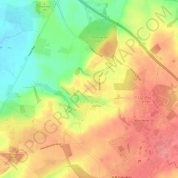
Name: Lighthorne topographic map, elevation, terrain.
Average elevation: 105 m
Minimum elevation: 60 m
Maximum elevation: 137 m
Other topographic maps
Click on a map to view its topography, its elevation and its terrain.
Big Clowes Wood
United Kingdom > England > Warwickshire > Stratford-on-Avon > Tanworth in Arden CP
Average elevation: 152 m
Napton on the Hill
United Kingdom > England > Warwickshire > Stratford-on-Avon
Average elevation: 113 m
Burton Dassett Hills Country Park
United Kingdom > England > Warwickshire > Stratford-on-Avon > Northend > Burton Dassett CP
Average elevation: 132 m
Upper Quinton
United Kingdom > England > Warwickshire > Stratford-on-Avon > Lower Quinton
Average elevation: 70 m
Lye Green
United Kingdom > England > Warwickshire > Stratford-on-Avon > Claverdon
Average elevation: 106 m
Cranhill
United Kingdom > England > Warwickshire > Stratford-on-Avon > Ardens Grafton
Average elevation: 57 m
Oversley Wood
United Kingdom > England > Warwickshire > Stratford-on-Avon > Alcester > Exhall
Average elevation: 64 m
Edgehill
United Kingdom > England > Warwickshire > Stratford-on-Avon > Radway
Average elevation: 157 m
Sutton-under-Brailes
United Kingdom > England > Warwickshire > Stratford-on-Avon > Stourton
Average elevation: 125 m
Walton
United Kingdom > England > Warwickshire > Stratford-on-Avon > Wellesbourne
Average elevation: 76 m
Arlescote
United Kingdom > England > Warwickshire > Stratford-on-Avon > Warmington CP
Average elevation: 148 m
Bishopton
United Kingdom > England > Warwickshire > Stratford-on-Avon > Stratford-upon-Avon
Average elevation: 64 m
Marlcliff
United Kingdom > England > Warwickshire > Stratford-on-Avon > Bidford on Avon CP
Average elevation: 41 m
River Avon
United Kingdom > England > Warwickshire > Stratford-on-Avon > Stratford-upon-Avon > Clifford Chambers
Average elevation: 43 m
Ashorne
United Kingdom > England > Warwickshire > Stratford-on-Avon > Moreton Morrell
Average elevation: 67 m
Bishop's Itchington
United Kingdom > England > Warwickshire > Stratford-on-Avon
Average elevation: 105 m
Pillerton Hersey
United Kingdom > England > Warwickshire > Stratford-on-Avon > Pillerton Hersey
Average elevation: 92 m
Pathlow
United Kingdom > England > Warwickshire > Stratford-on-Avon > Wilmcote CP
Average elevation: 84 m
Lower Binton
United Kingdom > England > Warwickshire > Stratford-on-Avon > Binton
Average elevation: 52 m
Ladbroke (Millennium Green)
United Kingdom > England > Warwickshire > Stratford-on-Avon > Ladbroke CP
Average elevation: 98 m
Winderton
United Kingdom > England > Warwickshire > Stratford-on-Avon > Winderton
Average elevation: 151 m
Ascott
United Kingdom > England > Warwickshire > Stratford-on-Avon > Whichford
Average elevation: 160 m
Edstone
United Kingdom > England > Warwickshire > Stratford-on-Avon > Wootton Wawen CP
Average elevation: 90 m