Geolocate

Abercorn topographic map

Click on the map to display elevation.

About this map

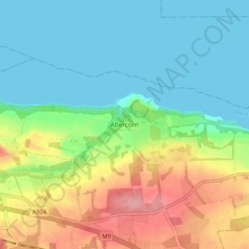
Name: Abercorn topographic map, elevation, terrain.

Location: Abercorn, West Lothian, Scotland, EH30 9SL, United Kingdom (55.97488 -3.49501 56.01488 -3.45501)

Average elevation: 36 m

Minimum elevation: 0 m

Maximum elevation: 109 m

Other topographic maps

Click on a map to view its topography, its elevation and its terrain.

Dechmont

United Kingdom > Scotland > West Lothian

Average elevation: 155 m

River Almond

United Kingdom > Scotland > West Lothian

Average elevation: 162 m

Deans

United Kingdom > Scotland > West Lothian

Average elevation: 164 m

Gear up for your next adventure:

🥾Light Hiking Boots - Lightweight and comfortable boots for day hikes
🧥Packable Rain Jacket - Breathable waterproof layer for unpredictable weather
🔦LED Flashlight - Powerful and long-lasting flashlight for camping and emergencies
🧥Softshell Hiking Jacket - The perfect balance of wind protection and breathability
🥾Trail Hiking Shoes - Durable shoes designed for rugged trails

As an Amazon Associate, this site earns from qualifying purchases at no extra cost to you.