
Southeast topographic map
Interactive map
Click on the map to display elevation.
About this map
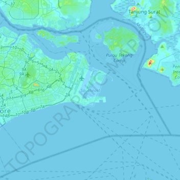
Name: Southeast topographic map, elevation, terrain.
Location: Southeast, Singapore (1.22269 103.85690 1.44660 104.13308)
Average elevation: 5 m
Minimum elevation: -3 m
Maximum elevation: 171 m
Other topographic maps
Click on a map to view its topography, its elevation and its terrain.
Singapore Botanic Gardens
Singapore > Central > Singapore
Singapore Botanic Gardens, 1, Tanglin, Singapore, Central, 259569, Singapore
Average elevation: 22 m
Bajau Hill
Singapore > Southwest > Singapore
Bajau Hill, Singapore, Southwest, 636921, Singapore
Average elevation: 15 m
Kallang River
Singapore > Central > Singapore
Kallang River, Bishan, Singapore, Central, 569983, Singapore
Average elevation: 26 m
Mount Faber
Singapore > Central > Singapore
Mount Faber, Singapore, Central, 099171, Singapore
Average elevation: 21 m
Fort Canning Park
Singapore > Central > Singapore
Fort Canning Park, Museum, Singapore, Central, Singapore
Average elevation: 19 m
Pearl's Hill City Park
Singapore > Central > Singapore
Pearl's Hill City Park, Outram, Singapore, Central, Singapore
Average elevation: 18 m
Bukit Timah Nature Reserve
Bukit Timah Nature Reserve, Rifle Range Road, Bukit Panjang, Northwest, 588406, Singapore
Average elevation: 52 m
Sungei Sembawang
Sungei Sembawang, Sembawang, Northwest, 757087, Singapore
Average elevation: 19 m
Botanical Garden Gallop extension
Singapore > Central > Singapore
Botanical Garden Gallop extension, Camwood Park, Tanglin, Singapore, Central, 257701, Singapore
Average elevation: 22 m
Gardens by the Bay
Singapore > Central > Singapore
Gardens by the Bay, Marina South, Singapore, Central, Singapore
Average elevation: 5 m
Istana Park
Singapore > Central > Singapore
Istana Park, Museum, Singapore, Central, 238902, Singapore
Average elevation: 19 m
Symphony Lake
Singapore > Central > Singapore
Symphony Lake, Camwood Park, Tanglin, Singapore, Central, Singapore
Average elevation: 22 m
Kallang Basin
Singapore > Central > Singapore
Kallang Basin, Kallang, Singapore, Central, 119587, Singapore
Average elevation: 9 m
Pulau Tekong Kechil
Pulau Tekong Kechil, Southeast, Singapore
Average elevation: 1 m
Lorong Halus
Lorong Halus, Pasir Ris, Northeast, Singapore
Average elevation: 6 m
Lilac Drive Playground
Singapore > Central > Singapore
Lilac Drive Playground, Seletar Hills, Serangoon North, Singapore, Central, Singapore
Average elevation: 20 m
Tanjong Pasir Laba
Tanjong Pasir Laba, Western Water Catchment, Southwest, 639937, Singapore
Average elevation: 4 m
East Coast Park (Zone H)
East Coast Park (Zone H), Tanah Merah, Southeast, Singapore
Average elevation: 5 m
Kent Ridge Park
Singapore > Southwest > Queenstown
Kent Ridge Park, Alexandra, Queenstown, Southwest, Singapore
Average elevation: 21 m
Palau Tekong Camp
Singapore > Southeast > Rocky Hill
Palau Tekong Camp, Rocky Hill, Southeast, Singapore
Average elevation: 5 m
Bukit Timah Hill
Bukit Timah Hill, Northwest, 589333, Singapore
Average elevation: 52 m
Gardens by the Bay
Gardens by the Bay, Marina South, Singapore, Central, Singapore
Average elevation: 5 m
Labrador Nature Reserve
Labrador Nature Reserve, Alexandra, Sentosa Cove, Southwest, Singapore
Average elevation: 11 m