
East Coast Park (Zone H) topographic map
Interactive map
Click on the map to display elevation.
About this map
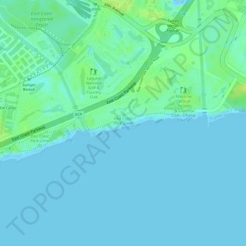
Name: East Coast Park (Zone H) topographic map, elevation, terrain.
Location: East Coast Park (Zone H), Tanah Merah, Southeast, Singapore (1.31412 103.96278 1.31707 103.97614)
Average elevation: 5 m
Minimum elevation: -4 m
Maximum elevation: 18 m
Other topographic maps
Click on a map to view its topography, its elevation and its terrain.
Pulau Tekong Kechil
Pulau Tekong Kechil, Southeast, Singapore
Average elevation: 1 m
Palau Tekong Camp
Singapore > Southeast > Rocky Hill
Palau Tekong Camp, Rocky Hill, Southeast, Singapore
Average elevation: 5 m